Station Area Planning
Creating Livable Places Through Transit
Transit stations can be much more than places to get on and off trains.
Transit stations open doors for how the areas surrounding a station can be used. They are springboards for enhancing existing neighborhoods and for creating entirely new destinations that support strong, lively, healthy communities.
Located within easy walking distance of transit stations, Transit-Oriented Development (TOD) that follows transit station creation can:
- Reinforce and enhance traditional neighborhoods and towns
- Revitalize and/or re-develop by-passed and under-utilized properties
- Redefine growth patterns to create walkable, mixed-use community spaces
- Expand mobility choices by supporting travel by rail, bus, bike and foot
Click here to download a video about TOD.
STATION AREA PLANNING
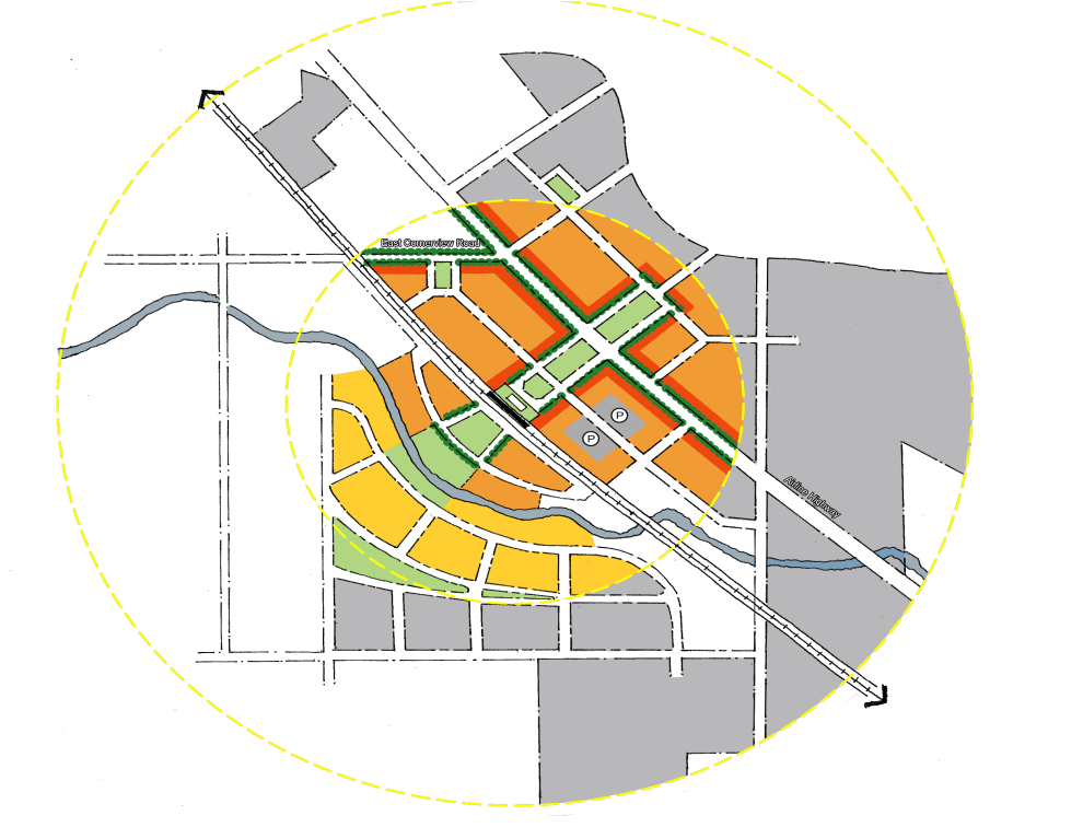
Station Area Planning (SAP) is the process of planning and designing the space within and around transit stations. SAP looks at the desired features of the station itself as well as the use of the land surrounding the station and how it relates to the community’s vision for the future.
SAP helps address the community’s relationship to a transit station and how the arrangement of development can be most beneficial to the neighborhood, community and region. For Oasis rail transit stations, the intent of SAP is to:
- Build upon local assets and opportunities, minimize negative impacts
- Offer new travel modes and connectivity for bus, bike and foot travel
- Concentrate mixed-use activity such as housing, office, retail, dining and entertainment
- Respect environmental, historic and cultural resources
- Secure a sustainable future for the region that is functional, environmentally beneficial and pleasant
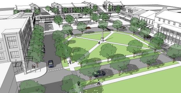
Ideally, plans for Station Areas should:
- Be compact and walkable
- Have an identifiable center and edges
- Center on a civic or public space at or near the transit station
- Support places as mixed-use destinations
- Provide connecting streets and sidewalks scaled to each neighborhood
The Oasis Rail Transit stations will be shaped based on location, community vision, the opportunities that exist for growth and public input.
Oasis planners are using the Tier 1 FEIS, the 2002 Land Use Vision Plan and its 2008 update and related information to establish baseline concepts for proposed Oasis stations. As the project advances in development, planners will work with local communities to form a more complete vision of their rail stations. The focus will be on how the space around the stations can best be used to improve neighborhoods and create livable, sustainable community spaces.
LIVABILITY PRINCIPLES FOR SUSTAINABLE COMMUNITIES
Six Livability Principles for Sustainable Communities are being used to help with Oasis Rail Transit planning and design:
- Provide more transportation choices
- Promote equitable, affordable housing
- Enhance economic competitiveness
- Support existing communities
- Coordinate policies and leverage investment
- Value existing communities and neighborhoods
These principles were developed by the Partnership for Sustainable Communities, a joint initiative of Department of Housing and Urban Development (HUD), Department of Transportation (DOT), and the Environmental Protection Agency (EPA). These principles can also be used in pursuing discretional federal funding opportunities such as TIGER grants, etc.
STATION TYPES
Oasis Transit Stations are likely to take the shape of one of three station types:
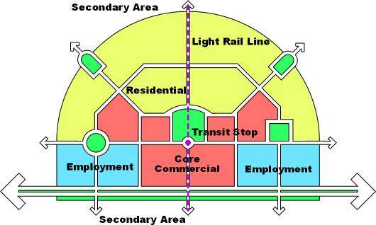
- Regional Serving Stations (Riverfront Transit Center, Milford)
- Located at major intercept points
- Serve modal transfer and service functions
- Include bus bays/staging areas
- Include Park & Ride facilities (may have limited walk-up opportunities)
- Support higher-density, mixed-used development
District Serving Stations (Red Bank/Fairfax, Ancor)
- Are connected to highways, major roads and main bus routes
- Provide bus/rail transfer
- Include Park & Ride options and has bike up/walk up potential as well
- Allow for High/Moderate density mixed-use development
Community Serving Stations (Columbia Tusculum, Newtown)
- Have fewer bus transfer options but may be served by bus feeder routes
- Have higher bike up/walk up potential
- Offer limited parking
- Allow for moderate density, mixed-use development
Unlike all the other Oasis rail stations, the Boathouse station will be a special event station. Used primarily for special events, it will have the highest level of bike up/walk up riders and no transit-specific parking.