Program Overview
The Eastern Corridor Program incorporates multiple solutions to address current and future transportation needs – new and expanded roadways, new rail transit, expanded bus routes, and improvements for bicyclists and pedestrians. The Program has been developed through a comprehensive project development process, which has included extensive economic development, land use visioning and environmental impact studies, all of which have been conducted in close collaboration with the Eastern Corridor communities.
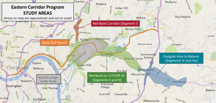
Click the image above to view a larger version of the Eastern Corridor Program map.
The 165 square-mile Eastern Corridor study area includes multiple political jurisdictions and communities, economic and employment centers, existing and future development zones, as well as sensitive environmental resources that are all being jointly considered in the development a long-term transportation solution for the area.
WHAT’S ALREADY BEEN COMPLETED?
A complex regional transportation improvement program like the Eastern Corridor involves extensive planning and is required by the 1969 National Environmental Policy Act (NEPA) to evaluate consequences to the man-made and natural environment before making any final decisions.
A comprehensive two-year planning study led by the Ohio-Kentucky-Indiana Regional Council of Governments (OKI) was completed in 2000. This Major Investment Study has guided development of the Eastern Corridor Program to date. To view additional Program development documents, click here.
Since 2002, the Eastern Corridor has used a two-tiered approach to develop the Program and fulfill NEPA project development documentation requirements. For more information about Tiering, click here.
TIER 1 STUDY (COMPLETE)
The Tier 1 Environmental Impact Statement (EIS) was completed in 2005 and the Federal Highway Administration (FHWA) issued a Tier 1 Record of Decision (ROD) in 2006. Together, these documents outlined a multi-modal Eastern Corridor transportation plan to undergo further evaluation in Tier 2. The Tier 1 plan included:
- A new 17-mile rail transit corridor extending between the Cincinnati riverfront and Milford (now known as the Oasis Rail Transit project)
- A 13-mile roadway corridor extending between Red Bank Road at 1-71 to just east of the SR 32/I-275 interchange in the Eastgate area of Clermont County. This corridor has been divided into implementation segments:
- Improved bus transit, including expanded routes, community circulators, and bus feeder routes to complement rail transit
- Upgrades to the existing transportation network, including local roadway improvements and bikeway connections
Preliminary project alternatives were developed as part of the Tier 1 study and a conservative range of impacts for the full multi-modal plan was identified. Tier 1 also established a context sensitive framework for the project by incorporating recommendations of land use vision plans and a Green Infrastructure Master Plan, both developed in concert with Eastern Corridor communities. Tier 1 was funded by a partnership of six local and state jurisdictions (the Eastern Corridor Implementation Partners) and was administered by the Hamilton County Transportation Improvement District.
Additional Tier 1 Studies
Additional studies were completed in 2008-2009 under the direction of the Eastern Corridor Implementation Partners to help address important environmental issues identified during Tier 1.
One of these studies involved an evaluation of channel movement patterns in the Little Miami River. This information was used to help locate and design a multi-modal crossing of the river. The second study consisted of an investigation of the Hahn Archaeological District located along the Little Miami River floodplain to better identify potential significant resources. Valuable information from both of these studies is being used in Tier 2 to help avoid and minimize impacts to these sensitive resources.
Click here for a pdf version of the Tier 1 Recommended Multi-Modal plan.
TIER 2 STUDY (CURRENTLY UNDERWAY)
Today, the Eastern Corridor Program plan as outlined in the Tier 1 EIS and ROD is undergoing Tier 2 study analysis. In Tier 2, broad recommendations made in Tier 1 are being examined in much more detail and evaluated for impact, function, context, constructability and affordability. Preliminary alternatives will be narrowed and refined, and the study will conclude by identifying preferred alternatives for the four projects to eventually undergo detailed design and construction.